











Sale
In Stock
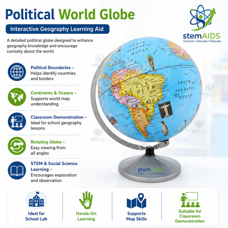
Political World Globe
Original price was: ₹950.00.₹465.00Current price is: ₹465.00.
Quick answer: The Political World Globe is a three-dimensional Earth model showing countries, continents, oceans and major world regions with their political boundaries. Unlike a flat map, a globe preserves the planet’s true spherical form, helping students compare relative positions and distances with less distortion than a map projection.
Description
The Political World Globe from LabEquip presents political geography on a three-dimensional Earth model. Unlike a flat map, a globe preserves the planet’s spherical form and helps learners compare the relative positions of countries, continents, oceans and hemispheres with less projection distortion.
The globe can support whole-class demonstrations, individual map-reading activities and general geography instruction, helping students build an accurate mental picture of world geography, borders and spatial relationships between regions.
What’s Included
- Political world globe on a stand or base
- Printed country, continent and ocean labels
- Teacher instructions or student activity sheet (where supplied)
Exact size, stand type and included accessories can vary by batch. Please confirm the current configuration with our sales team before ordering if a specific size or accessory is required.
Specifications
| Product Type | Political world globe (geography teaching aid) |
| Content Shown | Countries, continents, oceans, major world regions |
| Subject Area | Geography, social studies, general science |
| Recommended For | School and college geography classrooms, libraries |
| Diameter / Materials | Confirm with our sales team for the current batch specification |
Applications / Uses
- Locating countries, continents and oceans in three dimensions
- Comparing relative positions and distances between regions
- Supporting geography, civics and general knowledge lessons
- Classroom demonstrations and individual map-reading practice
Care & Maintenance
- Keep the globe away from direct sunlight to reduce fading of printed labels.
- Clean the surface with a soft, dry or slightly damp cloth; avoid strong solvents.
- Handle the stand and mounting axis gently to avoid loosening the globe.
- Store in a stable, dust-free location when not in use.
Why Choose LabEquip
LabEquip supplies geography and general-science teaching aids to schools and colleges, backed by responsive support from our team at [email protected]. Pair this globe with other classroom teaching models:
- Astronomical Globe Model
- Day and Night Cycle Teaching Model
- Four Seasons Educational Apparatus
- LabEquip Home
FAQs
What is shown on a political world globe?
It shows countries, continents, oceans and their political boundaries on a three-dimensional model of Earth.
How is this different from the Astronomical Globe Model?
A political globe focuses on countries and boundaries for geography teaching, while an astronomical globe typically emphasises latitude/longitude and celestial reference concepts.
Why use a globe instead of a flat map?
A globe preserves the true spherical shape of Earth, avoiding the size and shape distortions that occur when projecting the globe onto a flat map.
Is this suitable for classroom and library use?
Yes, it is commonly used in classrooms, libraries and geography resource rooms for reference and instruction.
How do I get exact size or material details?
Please contact our sales team at [email protected] for the current batch specification sheet.
Last Updated: September 2026
You must be logged in to post a review.
Bestsellers
Sale
Sale
Sale
Sale
Sale
Sale
Sale


Reviews
There are no reviews yet.